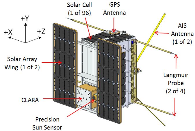
Schematic drawing of the NorSat-1 satellite. X, Y and Z coordinates represents a
satellite body coordinate system. The m-NLP probes are mounted on booms that
are deployed after its launch. The NorSat-1 is weighted approximately 16 kg and
has dimensions of 23 cm × 39 cm × 44 cm. Image credit: UTIAS-SFL
Description
With one of the aims to open a new era in ionospheric research, the first Norwegian scientific satellite NorSat-1 was launched from Baikonur, Kazakhstan on July 14th, 2017.
NorSat-1 is a multi-payload micro-satellite (~16 kg, 23 cm × 39 cm × 44 cm) that was commissioned by the Norwegian Space Center (NSC) and built by the Institute for Aerospace Studies (UTIAS-SFL) .
The satellite was launched into a polar orbit at approximately 600 km altitude where it is expected to operate for at least three years.
While its main objective is to monitor maritime traffic in Norwegian waters using a Automatic Identification System (AIS) receiver made by Kongsberg Seatex, NorSat-1 also carries two scientific instruments:
- Compact Lightweight Absolute Radiometer (CLARA) made by Physikalisch-Meteorologisches Observatorium Davos/World Radiation Center (PMOD/WRC), intended to observe total solar irradiation and variations over time.
- multi-needle Langmuir probe (m-NLP) developed at the University of Oslo (UiO). The mission is operated from Vardø and Longyearbyen ground stations in Norway.
With the m-NLP on board the NorSat-1 satellite is an ideal candidate to study the high-latitude and low-latitude ionospheric plasma.
With its sampling rate of up to 1 kHz, the m-NLP instrument aboard the NorSat-1 satellite provides an unprecedented opportunity to investigate plasma density structures down to a few meters in low-earth-orbit (LEO). Science objectives of the NorSat-1 satellite using the m-NLP instrument are:
- Primary objective:
- Identify and quantify the mechanisms that cause the generation of small-scale ionospheric plasma density structures.
- Secondary objectives:
- Map the global spatial characteristics of meter-scale plasma structures in the ionosphere and their dependence on meso- and large-scale ionospheric drivers.
- Provide physical understanding of ionospheric structuring mechanisms as the foundation for scintillation forecasts.
- Understand spacecraft/ionosphere interaction and its impact on in situ plasma density measurements
The m-NLP measurement data will be combined with data from the Super Dual Auroral Radar Network (SuperDARN) and the Defense Meteorological Satellite Program (DMSP) satellites to get the 'big picture' context of the ambient plasma.
Over the following years, the satellite will cross the equatorial and polar regions twice every 90 minutes, providing a wealth of data that would be able to help us better understand the mechanisms that dissipate energy input at larger scales by creating small-scale plasma density structures within the ionosphere.
System details
Details on the probes, boom system, electronics and instrument calibration can be found here.
|