An all-sky imagers (ASI) consists of three major parts: a fish-eye lense; an optical filter; and a photon counter. By using the fish-eye lense it is possible to image the aurora over the entire sky above the instrument, while the filter allows the selection of certain emission wavelengths which are characteristic for the mechanism causing northern lights. The photon counter then allows one to measure the brightness of the aurora. Due to the relatively low brightness of auroras, observations are only possible during the night, and when the Moon is not within the field of view of the imager.
Stations
Ny Ålesund
| Ny Ålesund |
| geographic |
geomagnetic (AACGM) |
| 78.92°N |
11.93°E |
76.24°N |
110.19°E |
The ASI in Ny Ålesund is located close to the Sverdrup Research Station operated by the Norwegion Polar Institute. The camera has two filters (5577 Å and 6300 Å) mounted on a single filter wheel. The earliest data available are from the 1997-1998 season. In 2010, the camera was upgraded to a high-resolution system (512x512 pixel). In 2014, we upgraded the system to the latest imager generation, installing a Keo Sentry 4ix Monochromatic Imager from Keo Scientific with two filters (5577 Å and 6300 Å) mounted on a single filter wheel. The "old" imager was installed in Skibotn from the 2014/2015 season onwards.
Longyearbyen
| Longyearbyen |
| geographic |
geomagnetic (AACGM) |
| 78.15°N |
16.04°E |
75.24°N |
111.21°E |
The ASI in Longyearbyen is located within the Kjell Henriksen Observatory (KHO) and comprises a high-sensitivity Keo Sentry 4ix Monochromatic Imager from Keo Scientific with two filters (5577 Å and 6300 Å) mounted on a single filter wheel. This imager has been calibrated and is in operation since January 2013. Before, we used a less sensitive system, which was moved to the KHO from the old Nordlysstasjonen in Adventdalen for the 2007/2008 observing season. The earliest data available are from the 1996-1997 season.
Andøya
| Andøya |
| geographic |
geomagnetic (AACGM) |
| 69.15°N |
16.03°E |
66.33°N |
99.88°E |
The imager on Andøya is located close to the Andøya Rocket Range (ARR) at the ALOMAR Observatory. It has been in operation since the 2002/2003 season and is currently the oldest imager in use. In most keograms from Andøya data, there appears a horizontal line of high intensity. This line is due to a blinking light within the ASI's field-of-view, as can be clearly seen when steping through the individual images from Andøya when the horizontal lines is present. We believe that this is from one of the LIDARs currently in operation at the ALOMAR station.
Skibotn
| Skibotn |
| geographic |
geomagnetic (AACGM) |
| 69.35°N |
20.36°E |
66.28°N |
103.41°E |
For the 2014/2015 season we moved the "old" NYA4 camera to Skibotn, a site close to Tromsø. Before it was stationed there, its brightness response was calibrated. Due to a slow internet connection the data will only appear on this website with a considerable delay. Contact Lasse Clausen if you are interested in expediting the process.
Calibration
Imager Orientation
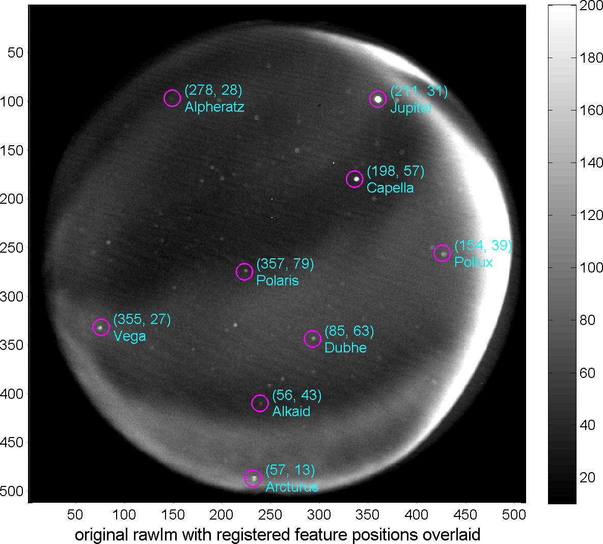
We use stars and planets within the field-of-view to calibrate all our imagers. In the figure to the right you see an example image of the Longyearbyen imager taken on 12/Jan/2013. There is some auroral activity, but also we observed several bright spots. The magenta circles mark the expected posititions of prominent stars/planets within the field-of-view. As can bee seen, the match between the expected position and the actual position is very good, showing that our calibration is valid, even towards very low elevations, i.e., towards the edge of the field-of-view.
You can download the calibration files for each imager using the link "download calibration file (IDL save files)" on the keogram overview page. These files are
IDL save files containing, among other things, the geographic and geomagnetic azimuth (relative to due North, positive East), elevation, and geographic and geomagnetic latitude/longitude of each pixel. The azimuth/elevation values are accurate to about +/- 0.5 degree.
If you don't use
IDL, you can use
Python to read these files and convert them into any format. The following code snippet will read an IDL save file, if you have
SciPy installed:
import scipy.io as scio

dd = scio.readsav(filename)
Brightness
The UiO_ASI-5 and UiO_ASI-6 cameras were calibrated at the UNIS calibration lab in Longyearbyen in January 2013. The cameras are Keo Sentry 4ix Monochromatic Imagers from Keo Scientific. UiO_ASI-5 (SN: 10112) is as of Januray 2013 operating at Kjell Henriksen Observatory in Longyearbyen. UiO_ASI-6 (SN: 10111) is located at the Sverdrup Research Station (Norwegian Polar Instititute) in Ny Ålesund.
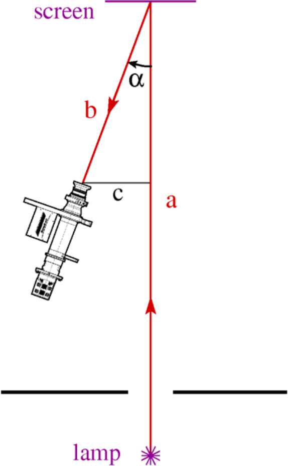 To calibrate the brightness response of the cameras, we use a setup as shown on the right. The calibration lamp was placed at a distance a from the diffuse screen; the camera was located at a distance b and at an angle α from the line perpendicular to the diffuse screen. The values for a, b and c during the calibration of UiO_ASI-5 and UiO_ASI-6 were: a = 8.463 m, b = 2.50 m and c = 1.00 m. An Oriel Model No: 63358 Quartz Tungsten Halogen Lamp was used (SN: 7-1633).
Five to ten exposures were recorded at each setting of the cameras. Then an average image value was computed for a circular section of all images in each settings. The calibration constants K (in [R/count]) are given in the table below.
To calibrate the brightness response of the cameras, we use a setup as shown on the right. The calibration lamp was placed at a distance a from the diffuse screen; the camera was located at a distance b and at an angle α from the line perpendicular to the diffuse screen. The values for a, b and c during the calibration of UiO_ASI-5 and UiO_ASI-6 were: a = 8.463 m, b = 2.50 m and c = 1.00 m. An Oriel Model No: 63358 Quartz Tungsten Halogen Lamp was used (SN: 7-1633).
Five to ten exposures were recorded at each setting of the cameras. Then an average image value was computed for a circular section of all images in each settings. The calibration constants K (in [R/count]) are given in the table below.
| camera |
filter (#) |
binning |
gain |
exposure time [ms] |
K |
| UiO_ASI-5 |
630.0 nm (1) |
4×4 |
3 |
2000 |
0.86 |
| UiO_ASI-5 |
557.7 nm (2) |
4×4 |
3 |
2000 |
0.85 |
| UiO_ASI-5 |
427.8 nm (5) |
4×4 |
3 |
2000 |
1.55 |
| UiO_ASI-5 |
777.4 nm (4) |
4×4 |
3 |
2000 |
1.49 |
| UiO_ASI-6 |
630.0 nm (1) |
4×4 |
3 |
2000 |
0.77 |
| UiO_ASI-6 |
557.7 nm (2) |
4×4 |
3 |
2000 |
0.85 |
| UiO_ASI-6 |
427.8 nm (5) |
4×4 |
3 |
2000 |
1.47 |
| UiO_ASI-6 |
777.4 nm (4) |
4×4 |
3 |
2000 |
1.66 |
The calibration constant K can also be found in the calibration files that can be downloaded from this site. When no calibration is available, K has a value of 1.
Cross-calibration
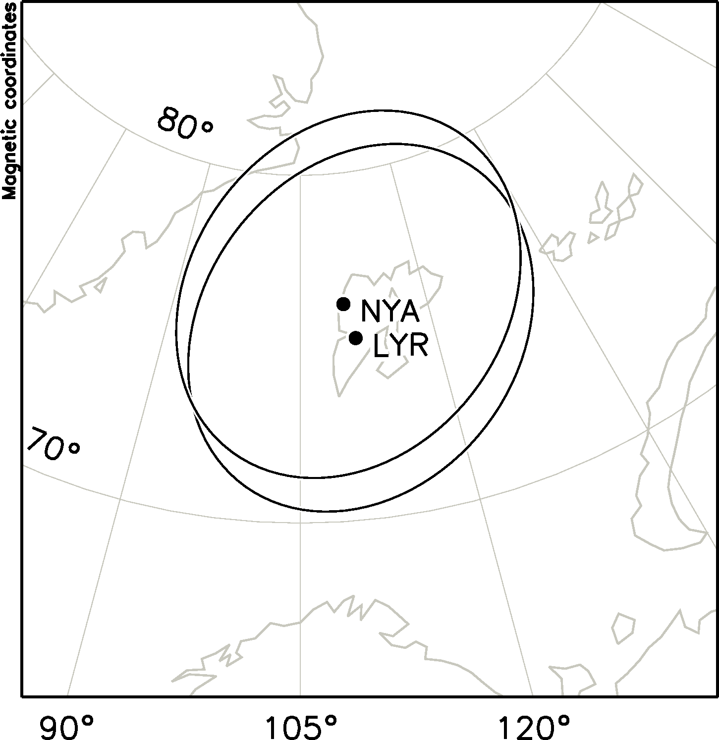
Since January 2013 the imager is Longyearbyen is calibrated to give brightness in units of Rayleigh, whereas the imager in Ny Ålesund is not calibrated. However, the imagers in Ny Ålesund and Longyearbyen share a large portion of their field-of-view; the figure on the right shows the fields-of-view of the two imagers at an altitude of 250 km with minimum elevation of 20°. The plotting is done in AACGM (magnetic) coordinates, hence the circular fields-of-view appear skewed. So, under the assumption of an isotropic light source located at a known altitude, we can calibrate the imager in Ny Ålesund using data from Longyearbyen. We begin by finding pixels in the field-of-view of the cameras which are closest (at a certain altitude), plot the brightness by the Longyearbyen imager (in Rayleigh) of that pixel against the brightness (in counts) measured by the Ny Ålesund imager at the same location, and fit a straight line to all data points within a certain time range.
Below we show an example of such a cross calibration effort for
December 05th 2013, 1400-1700 UT, using data from thered 6300 Å line. Several things have to be kept in mind when using such cross-calibrated results, though:
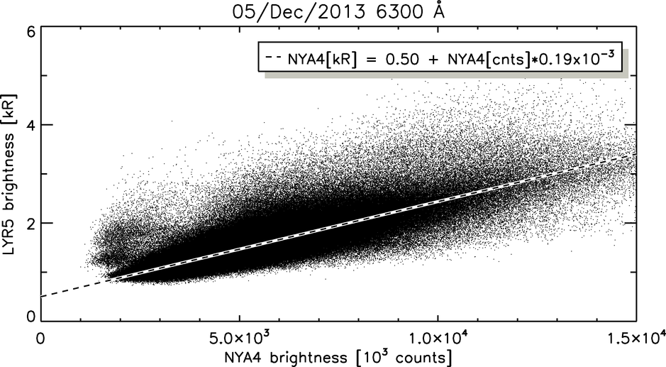
- As you can see, the linear fit does not cross the origin, as you would expect; this can however, be explained by sensitivity differences, i.e., that the LYR5 imager, which is the newer system, is more sensitive at lower brightness values than the older NYA4 system.
- There is still considerable spread, i.e., disagreement, between the two measurements, although they are supposedly from the same location. Obviously the assumption that all light eminates isotropically from one altitude causes some of that spread.
- Cross calibration also works for the 5577 Å line (see below), although the same caveats still apply.
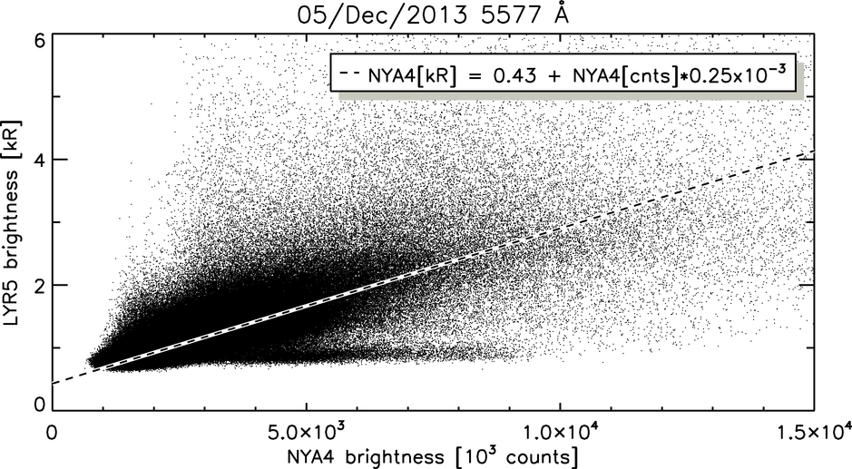
Nonetheless, using this method we can confidently determine the conversion factor for the NYA4 imager to within about 0.33 kR.